Issued by the National Weather Service on Wednesday April 26, 2023
KEY POINTS
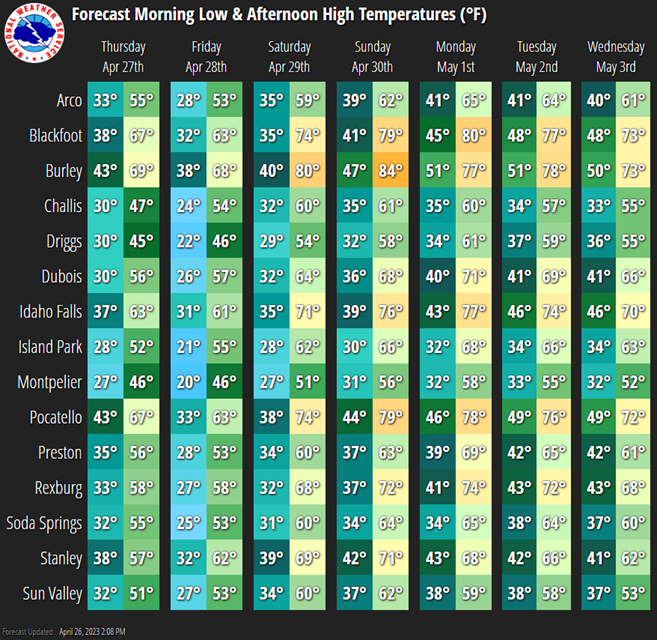
- Temperatures will warm significantly over the coming days leading to increased snowmelt through at least early next week
- Some areas will see mid-level snow melt of several inches through the end of the week, and then snowmelt will really increase over the weekend when the warmest temperatures occur
- Streams and creeks will swell to near bankfull
- Good news: No significant precipitation is expected through the weekend
- A broad storm will approach the west coast early next week which could bring slightly cooler temperatures, but could also bring rain back to eastern Idaho
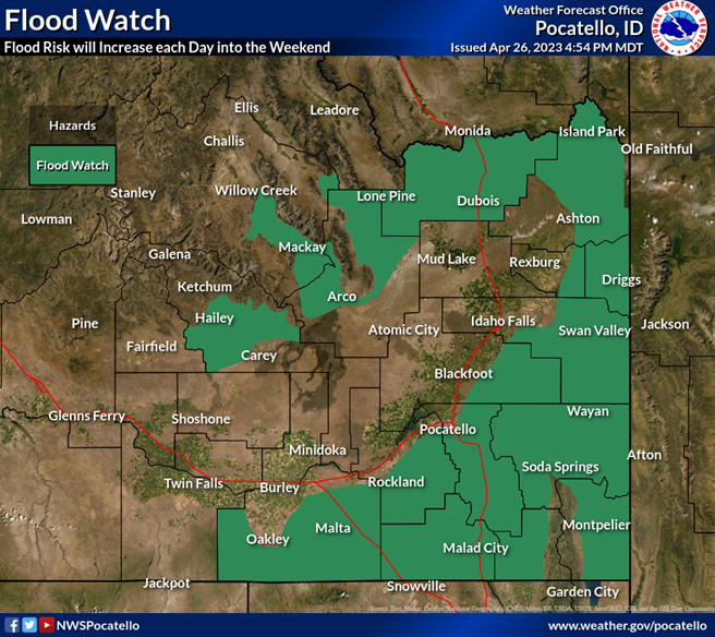
A Flood Watch is in effect through next Tuesday afternoon

DETAILS
Temperatures
- Temperatures will warm to well above normal by this weekend area wide
- Areas below 5,000ft have a greater than 95% chance of high temperatures above 70 degrees Sunday and Monday
- By Sunday morning most locations will see overnight lows stay above freezing, including areas above 5,000ft
- Temperatures may come down a little into early or middle of next week, but should remain warm enough to continue the snowmelt
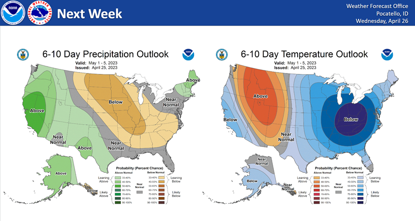
- The 6 to 10 day temperature outlook favors above normal temperatures into next week, so the warm temperatures are here to stay
Precipitation
- No significant precipitation is expected through the weekend
- The broad storm arriving along the California coast may move close enough to the Great Basin to increase moisture over central and eastern Idaho
- That storm is nearly a week away and finer resolution details need to be worked out, but additional rainfall could exacerbate any remaining flood concerns

Snowmelt
- Through Friday we’re expecting up to around 2-4″ of liquid melt in the low and mid elevations across the South Hills, the mountains east of Fort Hall, and into the Lost and Wood River Valleys
- Lesser amounts will melt in the Bear River Valley, Gem Valley, Teton Valley and Upper Snake Highlands where the snow is not as ripe
- Beyond Friday, snowmelt will really accelerate as overnight lows and daytime highs maximize
Rivers
- Strong rises on area creeks and streams are already occurring
- The Portneuf River at Pocatello is expected to reach bankfull by Friday afternoon and Minor Flood Stage by Sunday
- The Bear River at the WY border is forecast to reach bankfull by early next week
- The Big Wood River at Hailey is forecast to reach bankfull by early next week
- The Little Wood and Little Lost Rivers will likely spike higher daily through the weekend, reaching bankfull as early as tonight
- Monitor river and stream gauges here
Precautions
- Inflow to area reservoirs will increase dramatically, especially in smaller reservoirs and holding ponds – proactive releases may be necessary to keep up with inflow
- Locations that still have a lot of snow should move deep snow away from foundations of buildings and move equipment and livestock out of poorly-drained areas
- Clear snow, ice and debris away from culverts and other flow paths to allow runoff to flow away from buildings and other vulnerable infrastructure
- Monitor upcoming forecasts and river levels and be alert for possible Flood Warning or Flood Advisories
- If you observe flooding, please report your observations to the National Weather Service via phone, email, or social media when it is safe to do so.
View a new dashboard created between the Shoshone-Bannock Tribes and the National Weather Service

Additional Forecast Resources
For the latest forecast updates, visit www.weather.gov/pocatello, call us at 208-233-0834, and/or monitor NWSChat (nwschat.weather.gov/live/).
If you do not have an NWSChat account, please request an account here: nwschat.weather.gov/create.php.
To submit weather reports, photos, or to unsubscribe from these briefings, email pocatello.weather@noaa.gov.
—
United States National Weather Service
1945 Beechcraft Avenue
Pocatello, ID 83221
Phone: (208) 233-0834

